Leaving the Pacific behind, I drove in yesterday morning along Oregon Rte. 18. I had been looking for a good road in through the Coast Ranges and Rte. 18 looked fairly straight and direct on the map. Turns out it was a good choice. As it was described by the slow-talking, but amusing manager at the motel in Lincoln City, Rte. 18 is “subtle.” There are about 10 miles of slightly winding, slightly rising and falling, mostly two lane, well maintained road, but it is otherwise a good easily traveled route in from the sea. The one disconcerting sign was the one that warned of the possibility that the road might be closed by snow. I guessed that this would not apply in late July, however, and kept on.
I spent yesterday afternoon in Tigard, Oregon, a suburb of Portland. I had stopped to have Taliesin’s tires rotated and the brakes inspected and the front end aligned. This ended up taking nearly four hours, which I spent wandering through a Fred Myer store, where one can buy just about anything, but where I found only a need for a new stylus for my cell phone and a cup of coffee. It was good to have Taliesin in certifiably good shape before starting east toward the mountains.
This morning I got up early and walked around the southwest quadrant of Portland. This is one terrific city for urban hiking. It’s thoughtfully laid out, so that traffic is busy, but not congested. Trolleys, three or four cars long, move easily along tracks in the roadways, but never seem to get in the way. And there is plenty to see when you get out of the car and hoof it.
First, the city is lined with trees and filled with parks. The South Park Blocks is a long park area intercut with quiet cross streets that runs from Salmon Street in the center of the SW Quadrant six short blocks and two long all the way to Portland State University at the southern end of the city. There’s another Park Blocks in the northwest quadrant and the Westside Riverwalk follows the riverbank all the way from Steelbridge in the NW quadrant to Clay Street at the at the southern end. In a downtown section that is no more than two miles long by a mile wide, I counted no fewer than a dozen parks and squares.
And all the parks and squares, as well as the sidewalks throughout the city, are filled with sculptures; and not just statues of famous people (though there are a few of those), but an eclectic mix of modern, non-representational sculpture and more traditional forms, including water-filled concrete tubs with bronze beavers and ducks and seals and bears and all manner of creatures climbing around them. The parks are shady and well-designed for a leisurely lunch or a morning run. In the middle of the Riverwalk, there is a wading fountain (in which I, of course, waded, and an old upright piano with a sign that says “play me.” So, after listening to some excellent jazz being played, at the same time that a couple of other people (one with a guitar and the other with a harmonica) played some blues on the other side of the fountain, I decided that I should play the piano, too. I can’t say I gathered any cheering crowds, but nobody booed, either.
They city fascinates in other ways, also. I started my walk about 7:00 am, and there were people out washing the sidewalks, and the bricks in the courtyard square. It was a bright day, and fairly warm, but a gentle breeze moved through the city constantly, like city-wide air conditioning to keep it from getting too hot. There are water bubblers on the sidewalks: they each have four separate bubblers, so they look like thick bronze flowers growing everywhere. The city is a bicyclists’ city and there are bicycle lanes everywhere; the Portland Art Museum even has an exhibit right now of designer bicycles. The Oregon Historical Society Museum has a tour guide in a wheelchair (which may someday not be notable, but I haven’t seen one before). Oregon loves its coffee; there are lots of independent coffee roasters and coffee shops all over the city, and you can only get decaf if you take a decaf Americano. (Actually, this is true everywhere I have been in Oregon. Every little town has several small drive-thru coffee huts in parking areas or strip malls. Some of you may remember the photo developing drop-off places where you could drive up; that’s what these are like, only coffee, not film.)
Perhaps Portland’s most fascinating feature, however, is the food cart. There are parking areas that abut the sidewalks, and these are lined with “gypsy” wagons offering almost every imaginable cuisine. In just one of the smaller cart parks, I saw Mexican food, Thai, Iraqui, Korean (which offered tacos filled with Korean fillings), Indian, something called “Egyptian and New Yorker” that also offered Halal and Kosher foods, Hawaiian, Vietnamese, and burgers all sitting cheek-by-jowl along the sidewalk. Apparently these carts are the go-to for lunch in the city. People flood the streets at noon, queuing up to order, then sitting in the parks to eat.
I left the city about 2:00 in the afternoon, drove across the river to Vancouver, Washington, and started east along Rte. 14, following the Columbia River Gorge, but that will be a subject for my next entry.
Archive for the ‘Travels With Myself’ Category
A Good Road Inland and Urban Hiking in Portland
In Travels With Myself on July 25, 2013 at 1:43 amReflections Along the Oregon Coast
In Travels With Myself on July 23, 2013 at 2:22 am Every state I have visited on my trip thus far has had its own character, and I can feel it almost as soon as I cross the state line. I am amazed at how true this has been. I would think that the central plains would be the plains, the Rockies would be the Rockies, and the Pacific coast would not respect man-made boundaries; although I would not be as surprised to see that each state has its own response, its own attitude, to what nature has provided; but both seem to change all at once.
The Northern California coast is wild and open. The beaches stop going on forever and begin to nestle into rocky coves and little bays, but the sand remains flat and soft, sloping gently out to sea. As soon as I got into Oregon, the beaches became rugged and stormy. Wide dunes and incredible sand hills stumble toward the Pacific from the coastal mountains wherever the mountains themselves do not plunge right into the ocean. From the dunes, a hard, dark sand, glittering with mica flakes sits in great tidal plains. And the wind suddenly comes roaring onto the shore, 35 to 50 miles-an-hour. Even when the road cuts back behind the dunes and hills and sections of forest, the wind gets through and rocks Taliesin as I drive along. Walking on the beach feels like flying, especially when the morning clouds still cling to the rocks and sand. Nobody seems to swim here, they wade and splash in the shallow tides, and sit huddled on logs along the beach.
Along the back of the beach, in the dunes or pushed up against the hills, are seemingly endless tangles of grey and white driftwood; from twigs to great stumps, a testament to the power of the sea and the wind. At the tops of the hills the trees all lean inland, their hair permanently blown back. A redwood slab cut from a tree brought down in the 1990s, and displayed at a state park visitor center shows an oval shape, with the seaside rings crushed together and the inland rings spreading out as the tree grew against the wind.
The Oregon coast inspires something of the romantic in me. I could walk these beaches for hours, stopping to look at the sea birds, scanning the outer rocks for seals (which never came in while I was there), letting the waves roll in from a great distance to lap across my bare feet. I could dance across beach floor, stopping only to draw hearts in the sand, and sit a long, long time on driftwood logs thinking of my love. If I were an artist, I would paint these shores as Maxwell Parrish fantasies, but put real people on them, wading in the waters, playing catch with their children, calling to their ecstatic dogs, eating their cold lunches, laughing and playing. If I were a poet, I would write free verse, as free as the wind and waves and sand; I would write metaphors that dipped and soared like the sea birds or stood majestic like the cliffs; they would seem solid and unyielding until the reader could see that they, too, are changed inevitably by the wind and the sea.
But I am an actor, so I see the character of the coast, and as I walk the streets of the coastal towns, now teeming with the itinerants of summer (myself included), I think I can see that character in the shop owners, the people who live here and are part of the scenery, as natural in these hills and coastal plains as the elk and the seals and the sea eagles. They are bemused by the people passing through, but separate from them.
The change in character is shown, also, by man-made objects, such as road signs and the ways that people and places present themselves. In California, I was asked by a blue sign every ten miles or so to report drunk drivers; shortly after I crossed into Oregon, one white sign politely asked me to please not drink and drive. In California, everything is famous; in Oregon, they are historic: historic views, historic beaches and coves and ports, historic landmarks. The Northern California coastal highway is tie-dye and bright colors and a public radio station in Redway that broadcasts the Cannabis Report every morning. The Oregon coast is solid and patient; it takes itself seriously, but with a quiet sense of humor about it all.
Tomorrow I turn inland toward Portland. I will miss the Pacific coast. I have stopped frequently to look, to walk, to rest, to be refreshed, and to wonder. I cannot imagine rushing up and down this coast without paying attention to it. Maybe that’s why the major north-south highway is at least 50 miles inland, away from the distractions, so people and commerce keep moving.
So far, I have passed through at least a little bit of fourteen states. I will pass through at least six more new ones as I head east again. I can’t wait to meet them all.
Days of Wine and Redwoods, and Down to the Sea Again
In Travels With Myself on July 21, 2013 at 2:32 am As soon as I crossed the Golden Gate Bridge, US 101 became the Redwood Highway, but it wasn’t until 155 miles up the road that I reached Willits, which calls itself the Gateway to the redwoods. And it was 63 miles further before I saw my first actual, identifiable, up-close-and-personal redwood trees. Along the way, the state seems to bunch certain things together by regions.
As I left Cloverdale yesterday morning, I was quickly into the northern wine country. There were vineyards and wine tastings every few miles. I immediately thought of two things. First, I thought about the movie “Sideways.” which tells the story of two guys trying to taste their way south through the state. While that certainly seemed suddenly a very plausible sort of plot, it also seemed as though it might have taken them a week just to get from Ukiah to Cloverdale. I also thought that it is fortunate that I am making this trip sober (I have had only one alcoholic beverage since leaving Connecticut), because if I were a drinking man I might not get to Oregon for another month. One thing that this does explain, I suppose, is why there are so many signs along the highway exhorting people to report drunk drivers by calling 911.
Once I got into redwood country, however, the theme changed. Now there were frequent signs indicating yet another drive-thru tree, or a house made out of a single, hollowed out redwood trunk. And every one of them is apparently the world famous one. There were also a lot of references to Bigfoot, who probably stays hidden these days because he, or she, is simply embarrassed, mortified even, by all the somewhat tawdry attention.
US 101 travels all along through some really beautiful country. The elevation never tops much above a thousand feet, but it feels much more mountainous, as the highway bobs and weaves and dodges its way through the Coastal Ranges of Northern California. In New England, the mountains are green. They have a lush coat of both evergreen and broadleaf trees. This is what makes them so especially beautiful in their October colors. Here, the trees are mostly evergreens, but they stand alone or in groves much of the time, with a gold-brown carpet of mountain grasses between them. This relative sparseness shows the line of the land more clearly, and accentuates the height.
I continue to be surprised, and often amused, by what I find in the small towns that offer a chance to get off the highway for a while. Cloverdale has the “Famous Owl Café.” Hopland is home to the Real Goods Solar Living Center. In Laytonville, which really seems nothing but a small area of shops along US 101, the Pour Girls Coffee shop serves up organic espresso, while across the street at the combination hardware store and supermarket, a fellow was collecting money to start a local non-profit radio station. On the way out of town, I passed a tie-dye shirt store, a Consciousness Center, and a place that calls itself “Area 101” and is festooned with crude paintings of UFOs and grey aliens. There seems to be nothing at all in Leggett except that drive-thru tree, which gets it a mention on the tourist map, and a single store.
I stopped last night in the Redwoods National Park. I got off the highway in Myers Flat and followed the Avenue of Giants for about ten miles of winding, narrow road among these enormous, fascinating trees; alongside wide, dry creek and river beds. I stopped at an RV park in Redcrest, which, with its campsites and cabins and gift shop, was pretty much all of Redcrest on the east side of the road. On the other side of the road was a post office, a little building housing the “Nesting Place,” which sells a lot of old, interesting junk, a shuttered gas station, and a restaurant and gift shop associated with an old twenty-square-foot one-room house carved a long time ago into the trunk of a living redwood tree. There was also what seemed to be one house set back from the road, which I only noticed because it had a TV antenna mounted on the roof. I mention this because if that house got television signals, then it was the only signal getting through. I discovered that I was completely cut off electronically: no cell reception, no 4G, and no WiFi.
My reaction to this sudden isolation from the outside world was two-fold. First, I was frustrated. I rely on my electronics to keep me connected to someone important in my life, who I knew would worry if she didn’t hear from me. All I could do was send a text that wouldn’t go out until I got back in range again in the morning. Knowing that I couldn’t reach her even to let her know I was all right made me realize how much I had come to count on our daily texts and occasional phone calls. I also realized that there were times along this trip when I could be cut off from even emergency communications. What if something happened and I needed help? How did we deal with these things before our modern electronics? How must it have been to know that someone you love would, by necessity of work or travel, be completely cut off from you for weeks or months? How would it feel to be exploring a country as big as this one when it meant being really, completely alone?
My second response was to recognize that it felt especially quiet. I loved being in those woods. I wasn’t actually alone, just among strangers who were friendly and helpful. I had all my basic necessities met, and I was comfortable. When I woke this morning, I realized that I had slept very well and awakened rested and eager to get back on the road. Of course the first thing I did was to listen for the sound of my cell phone, letting me know that I was back in touch with the rest of the world.
Back on my way this morning, I made my way down through the redwood hills. The landscape began to look more like home, like Western Massachusetts or Vermont or New Hampshire. The mountains were all green and lush, the road moved more lazily through the valleys and passes, only occasionally snaking scarily along the side of a cliff – or perhaps I am just getting used to it.
The day had started cool and hazy, and that remained when 101 turned to the shoreline; but the beaches of northern California were beautiful in spite of (and even because of) the weather. At Clam Beach, I walked across a quarter-mile of gently waving dunes to a wild beach untouched by commerce. There was, it’s true a somewhat run-down, small state beach with a few scruffy-looking campers and a chemical-toilet outhouse; but these disappeared from sight as soon as I crossed the first row of dunes, leaving the beach clean and unspoiled. Later, I pulled well off the highway, past a busy little state beach area and resort, down a slightly winding narrow road to College Cove, where I walked from the dirt parking area down a walking path through woods and across the top of the cliffs, then down a steep set of rustic, well-worn stairs to find one of the most breathtaking coves I have ever seen. I ate a light lunch on the beach, then stayed nearly an hour, walking along the beach, and sitting to watch the water roll up onto the sand and crash against the rocks. There is something about a wild, empty beach, especially one nestled among the cliffs and rock formations, that restores me and helps me reconnect to what is real in the world.
Then it was back into the hills and redwoods for a while as I made my way up the coast to Crescent City, where I am spending the night. Along the way I saw three female elk standing quietly be the side of the road. All in all, a good day.
Keeping it El Camino Real
In Travels With Myself on July 19, 2013 at 3:12 amI took El Camino Real from Palo Alto to San Francisco. It is, in fact, one long, wide city street through a lot of small cities and suburbs which are surprising different from one another. Simply crossing the line from one to the next, the street would go from well-kept, clean, busy storefronts to fading paint and disrepair, and empty windows, then back to pretty.
I like driving these kinds of streets. Sometimes traffic can be a bit congested and slow, but as often as not, it moves along at a reasonable town and city pace, giving me time to look around a bit. Along the lead-up to San Francisco, I saw less and less of the Spanish influence, and more of typical small town America: simple storefronts, with signs that tell you what the place is without excess glitz or neon. I also began to see more of the Victorian: three or more floors with window bays from ground to roof, and the gingerbread moldings and multi-colored walls and trim. And there was shift into more Asian influences in the kinds of stores, and the mix of the pedestrians; something which had actually begun to happen at least as soon as I got past Santa Clara and into the San Francisco ex-urban area.
What occupied my thoughts, however, was a certain disinterest I have become aware of in myself to spending time in large cities this trip. I very much enjoyed Irvine, but skipped by L.A. along the shore. I had earlier stayed to the outskirts of Cincinnati, stopped only for a photo-op in Kansas City, stayed well south of Major cities like Chicago, Denver, and Salt Lake. And now I found myself driving straight through San Francisco. It was a good drive, but I didn’t feel the need to stop. El Camino turned into San Jose and then Laguna, and because Frisco is laid out in a grid, that took me all the way to the Golden Gate Bridge. I passed through residential areas, rich and poor, through business districts and past malls. I went up some of the famous hills and down the other side. Actually, I don’t know which was scarier, coming to stop signs at every cross of a steep incline, or coming to them on the way down. At least going south to north I didn’t have any moments when I was looking down a long hill with nothing but the bay below me.
I will interject here that nothing I have ever seen of pictures or read of descriptions of the Golden Gate Bridge prepared me for the first sight of it on the approach along US 101. It is magical. A rock face jutting up from the bay hid the southern end of the bridge, and the northern end was off in the distance, but the bridge itself hung across the sky, its towers still shrouded in low clouds and mist at ten-thirty in the morning. I don’t know what I expected in crossing it, but it’s so wide, with a separate sidewalk along the edge, that if it weren’t for the climb and descend of the span, it wouldn’t seem like being on a bridge at all; more like an interesting erector set tunnel of some kind. And at the far end, the road climbs through the hills as if the bridge has brought you to some fairy tale land where a castle awaits. Alas, there is no castle.
Finding parking for my nineteen-foot van can be problem on city streets, of course (parking spaces can be a premium item at any time), but I have been able to find enough standard spaces I could pull into so that stopping wasn’t impossible (parking garages are, of course, out of the question because of Taliesin’s height). Maneuvering through city traffic can also be tricky sometimes, but I’ve driven a van this size in Boston before, so that doesn’t really intimidate me. No, I think that it is simply not what I am looking for this trip. I will return to L.A. or San Francisco again someday, but on purpose when I want to spend a good long time there. For now I am more interested in the spaces between the cities.
On the other hand, I have very much enjoyed some small cities along the way. I took a break from the highway at Petaluma today. I bought walked around town, stopping at a music store and to mail a post card, ad had a light lunch of chilled blueberry soup and lemonade at a restaurant called the Wild Goat in a building called Petaluma Mills. I then stopped at a Visitor Information Center in Santa Rosa, where there are statues of Peanuts characters in the parks. I find that I spend more time than I intend in some of these towns and small cities. They are always warm and comfortable, without a lot of hustle (either the hurrying kind or the commercial kind). I smile at people and they smile back, clerks and wait staff seem genuinely happy to be there and to have me stop by. I know that I could find such people and such places in the larger cities, too, but I would have to look for them rather than find them on every corner.
I am learning, I think, that this trip is about going places, not being places. Cities want to hold you for a while, show you the sights, help you have a good time. Small towns are happy to have you just pass through or stay, whatever suits. They aren’t destinations so much as part of the journey.
North from the Coast and Inland
In Travels With Myself on July 17, 2013 at 4:19 am Looking at a map of California, one could argue that I 5 is the transportation spine of the state, running as it does from the Mexican Border pretty much right up through the center of the state to Oregon. If so, then US 101 (and CA 1 where they overlap) is one of the major arteries running through the western part of the state delivering people and goods to the coastal areas and agricultural heartland. I am not knowledgeable enough about plants to know exactly what was growing, but 101 north of Santa Barbara passes through some of the most amazing farmland I have ever seen. And once you get above San Luis Obispo you are in wine country, and the locals will tell you that the wineries around Paso Robles rival the Napa in size, number and quality. Whether vegetables or grapes, the fields are green and lush, stretching from the edge of the highway to the edge of the hills in the distance; almost as far as my admittedly presbyopic eyes can see.
The beauty of this part of the country is only rivaled by the wind. There seems to be no place west of Colorado where the heat of the afternoon is not accompanied by winds which seem determined to blow directly across whatever road I am driving on. Now, those better versed in meteorology and related issues can correct me on this, but here’s what I think I have learned. Cooler ocean air on the Pacific coast comes ashore and forces the warm air up over the coastal ranges, where it cools and then rushes down the other side into the valleys. That rush of wind creates gusts that sweep across the center of California, forcing the air that has been warmed all morning to rise up over the next batch of mountains (the Cascades, perhaps, or the Sierra Nevada), cool, and rush down in its own turn into the next valleys. This process then continues up over the Rockies into the valleys and plains of Utah and Western Colorado. Because major routes like US 101, I 5 and I 15 run primarily north to south, the winds blow across them rather than following them. None of which makes it easier in the understanding to drive in it.
I have often been taken by the way communities choose to identify themselves. In Connecticut, for example, Willimantic calls itself “Thread City.” (I have never felt that “Romantic Willimantic” had any real chance of getting traction.) Along those lines, Los Alamos has a sign at the city limits proclaiming that it is the “Valley of the Cottonwoods,” while Buellton claims more mundanely to be the “Home of Split Pea Soup.” Also, it is impossible to drive more than a few miles without encountering a “San” or a “Santa” something. I had never imagined there were so many saints in the Catholic pantheon; from Antonio and Ardo to Barbara and Clarita, through Lucas and Maria to Monica and Paula; which doesn’t even include well-known ones like Diego and Luis Obispo and Juan Capistrano.
The preponderance of saints, however, also means an abundance of missions, which are as plentiful here as lighthouses in New England. I stopped today at Mission San Miguel Arcangel, just above Paso Robles. An artist friend, Eric Spencer, whom I had lunch with in Paso, had told me it was worth the visit. What I found was interesting for its odd mix of the worshipful, the historic, and the touristy. My first view of the Mission was a brick bell tower .around the compound, I discovered simple, but surprisingly beautiful cactus gardens, a cemetery where hundreds of Native Americans had been buried, but where the prominent gravestone was for a family named MacDonald. When I got around to the front of the Mission, it looked for all the world as if it had been plucked from old movies and television shows: Zorro, or the Cisco Kid.
The church itself, and the attached structures, which house the monastery buildings and the gift shop, were well preserved, the stucco walls patched with plaster, and the red tile roofs solid. The grounds were dry and dusty, but filled with interesting artifacts, like an old olive press and an abandoned well sealed with a large stone, and incongruously, a small cannon. A walk through the well-marked self-tour, showed me the tools of 18th century mission agriculture, the weapons of the Spaniards who once ruled here, and the miscellany of everyday life, tucked into small, dark rooms and curious alcoves and passageways. The outer wall of the courtyard was allowed to show the effects of time and wind and human conflict, the top broken in places, the gates dark with age and gapped between the boards.
But placed within these historic contexts there was something of the tourist and the theme park that caught my eye. A building that contained the rest rooms had been placed at one end of the compound such that it created behind it a gate to nowhere. And the structure had been designed with the illusion of bricks showing through crumpled stucco, large fake holes revealing fake bricks. The effect was, I admit, successful in a theatrical sort of way, but since the actual historical structure showed no such wear, I wondered why it was thought necessary to fake it on the bathrooms. In the gift shop, the usual selection of Christian religious symbols, rosaries and books about the mission were interspersed with oddities like plastic boxes of sharks’ teeth and small ocean shells, tee shirts, fake Spanish coins, and expensive bottles of Mission San Miguel olive oil.
The inside of the sanctuary, however, was spectacular. The church contains some of the last remaining original frescos of the period. It’s hard to describe adequately the soft blues of the pillars painted along the walls, the brilliant yellows and pinks of the space around the altar, the great starburst above the altar itself, with the all-seeing eye in a pyramid at its center, like the eye on the back of a dollar bill. To the right, a long narrow staircase, painted a brilliant blue leads to a pulpit that floats against the wall, while a blue “roof” seems to hang dangerously above it. (For those following my travels on Facebook, I will post photographs. Told of these things ahead of time, I had remembered to bring my camera.)
I left the mission feeling refreshed and heartened. As I head north, I am finding that California has more surprises for me. Every time I take a break from the highway, in the small towns, the little cutoffs or the scenic rest areas (and I get off the highway often to let go of the stress of driving against the winds), I discover small treasures, and not a few great inspirations.
North to Malibu
In Travels With Myself on July 15, 2013 at 4:54 pmFive wonderful days visiting with my daughter, Suzanne, and Jonny Rose in Irvine, CA. But now I am back on the road again and headed up the Pacific Coast Highway. Spending the night north of Malibu at the Point Mugu State Park. The Santa Monica Mountains are to the east, the Pacific to the west, and little more than CA 1 between them.
I had supposed that I wouldn’t get much to see that I haven’t already seen until I’d gotten north of the great sprawling mega city that is Los Angeles and its suburbs and surrounding towns. Technically, I won’t be away from all that until tomorrow when I finally get to Oxnard, but even passing L.A., Route 1 is an adventure.
Let me say, first, that Irvine is a beautiful place. I have never seen such wonderful parks and clean, well-kept, tree lined (especially cypresses and palms), well manage streets. Six to eight lane roads, with center dividers, allow traffic to spread out, which makes the number of cars manageable. L.A. may be a great big freeway, but Irvine is a great big mall, with islands of residences that seem to merge with the malls as much as separate them. Still, even the sameness of the sand-colored architecture can’t keep the city from being laid back and pretty. The campus of the University of California at Irvine is an enormous park; and there are bicycle lanes everywhere, to further simplify the issues of traffic and commuting.
And the ready availability of the beaches at Laguna and Newport, just to name two, makes it an easy place to want to stay awhile. I am, however a New Englander by nature and nurture, so I am not entirely unhappy to put southern California behind me.
The drive up the PCH through Los Angeles County starts along the beaches. I made a stop at Huntington Beach, which is exactly what I pictured California beaches to be. Laguna was a fairly narrow beach between the mountains and the sea, but Huntington is wide open. I walked across a parking lot that already seemed to go on forever, then across a flat sandy stretch that was grossly under-utilized on a Sunday morning in July. Even with the generous paved path for bicycles and roller-blades, the volleyball courts, and the grandstand for surfing competitions, there seemed more than enough room for easily hundreds of thousands of beachgoers. The water came in over a shallow beach, making room for waders and swimmers and boogie boarders alike. At the north end of the beach, just past the great pier, however, oil platforms stood prominently above the horizon.
There were those sorts of contrasts all along the way. There were long sections with vast beaches to the left and vast cliffs at the road’s edge to the right. There were stretches where the shopping centers and strip malls seemed to go on forever. And there were stretches where the beaches on the left competed with industry on the right, including what looked like oil wells, with their ridiculous-looking, yellow, bobbing duck pumps rocking up and down. Traffic was smooth and easy nearly all the way to Santa Monica, then congested and slow, with cars lined up on both sides until well past Malibu.
As I start up the coast, I feel as though I am still moving away, but as the mid-point of my trip draws nearer (somewhere around San Francisco), I am already feeling some homesickness. Perhaps, this will pass for a while as I explore the little towns along this incomparable coast, but I know now that there are many kinds of barriers. When I got to the Pacific, I could go no further west, and so I turned north. But I also found that I had other barriers, the ones that aren’t dependent on mountains or oceans, but dwell within us. Now that I will be leaving the mountains behind me and following the edge of the ocean that has stopped me, it’s those other barriers I need to cross before I turn toward the east, and home.
Irvine, At Last
In Travels With Myself on July 10, 2013 at 8:26 amThere may be more interstates and major highways per square mile in Los Angeles than anywhere else in the United States. It’s actually impossible to go some places without having to get onto a stretch of highway. Or two highways. Or three.
But get off the highway for a distance and you will find clean, bright, beautifully landscaped cities lying practically on top of each other to make up the sprawling urban landscape of Southern California. The streets are lined with trees, a variety of broadleaf and the ever-present palms; behind the trees, walled communities and shopping malls seem sometimes to be all one huge building, with golden beige stucco walls and red tiled roofs. But the sameness is too earthy, too organic, to be boring; too stunning in its simple elegance to be unremarkable. I can imagine these buildings pushing up from the ground, fully formed.
I am in Irvine tonight, which is and is not Los Angeles. Orange, Tustin, Irvine, and all the other names that float across the map are indistinguishable from Los Angeles. Even San Bernardino and San Diego seem feathered into the edges of Los Angeles, like brush strokes painted on the map so that the lines blur and disappear. But Irvine is not yet the Pacific, for that I will have to go still a few miles further west, or south through the city streets to Newport Beach, or through the hills to Laguna. On the map, it looks as if I should be able to see it, hear it, reach out and put my fingers into it; but in fact, I am not quite there yet.
I’m not really even free of the mountains. Approaching from the Mojave Desert, I kept thinking I had crossed my last summit, made my last descent into the valley, only to see another hill rise up in front of me and the road ahead follow it up to the top. Now, though, the hills are lined with homes, man-made outcroppings, and I watch for bicycles rather than fallen rocks.
I like this city, what I have seen of it so far. It feels like it belongs here. New York has always felt awkward to me. It stands so heavily on the ground. I lose the sense of the island underneath it. The concrete and steel and glass seem to weigh down the earth itself. Boston, with its 17th century avenues running hither and thither, and the Government Center looming over Quincy Market, sometimes seems about to topple into the bay. Here, everything seems to sit lightly on the surface. It’s not true of course. It’s just an illusion created by all the palm trees and sand-colored architecture. The streets are six to eight lanes wide through the middle of the city, and when the traffic begins to build, the streets and highways get weighted down, cease to float. I’ll be here for four or five days. This will bear watching, this odd juxtaposition of lightness and compression.
But for now, I feel light, too. I have made it almost to the ocean.
On the Road Again
In Travels With Myself on July 9, 2013 at 3:36 amAfter three days of the most wonderful R&R at the home of my sister Linda and her husband Layne in Beryl, Utah, I got back on the road. Most of the territory I covered yesterday and today was simply more mountains, more desert, more wind; so I won’t try to describe the whole trip. Instead, I will offer some observations from the road.
It’s easy to look at a map and segment out the features on it: Here’s a mountain, there’s a river, down there’s the plains and up there’s a lake. But when you get on the road and start to experience the country at ground level you quickly realize that it doesn’t quite work that way. From Colorado to California, I have never left the mountains, never ben far from the deserts or valleys or plains. When I finally make it to San Bernardino tomorrow, I will only then really be getting out of them.
The hardest part of driving across the wide open spaces of the southwest is the wind. Speed limits are 70-80 mph along the interstate, but the crosswinds keep larger vehicles’ speeds down, for fear of being blown across the road by a sudden gust. Next hardest is the long upgrades and downgrades, sometimes 20 miles or more of either straining the engine or testing the brakes. From St. George, Utah to Glendale, Nevada, for example, it is almost entirely downhill. I have a lot of new respect for the cross-country truckers who make their way along these highways every day.
Someone asked once if I was going to take Rte 66. It’s a fun idea, but the fact is that it almost doesn’t exist anymore. I took a segment of the historical Route 66 from Barstow to Victorville. It’s still a nice two lane road through the Mojave desert, but along most of its length it is dotted with the fossils of motels and restaurants and tourist stops that long ago stopped attracting tourists. Alongside these are small homesteads and ranches perched like dollhouses in a great sandbox, their yards closed in by fences. Some of the homes still look as we might imagine them, 150 years ago, simple square, squat buildings with a water tower perched on a wooden tower in the yard. It’s a long way between towns and cities that are more than a few aging buildings set back away from the main road.
I think I believed when I started this journey, that all I had to do was just keep going; that the driving itself would be relatively easy; I’ve been practicing for 50 years, after all. I thought that I would certainly feel afraid or uncertain at times, that I would feel lonely; but I’m discovering that being so far from home is about more than just that. Since I hit the Rockies, I have been displaced. I’m a New England boy. I’m used to the special conditions and quirks of New England’s weather, its topography, its ecology. I could learn to live somewhere else, I suppose, but I’m not well suited for some of what I’ve encountered so far.
I have made a commitment to the road, without knowing where the road would lead me. The result is that I have been unprepared. This is the nature of our journeys of discovery; this is the nature of our lives. We think that we know the road ahead, that it won’t be all that different from the road already traveled. We put one foot in front of the other and, if we’re paying attention, we are constantly surprised, sometimes but not always, pleasantly.
I will be in Los Angeles tomorrow. I will visit there a few days, then start the second leg of my trip: the drive up the west coast highway. I suddenly have absolutely no idea what’s in store for me. But I will continue to try to pay attention, and write down what I can of it.
Two Canyons
In Travels With Myself on July 5, 2013 at 4:45 pm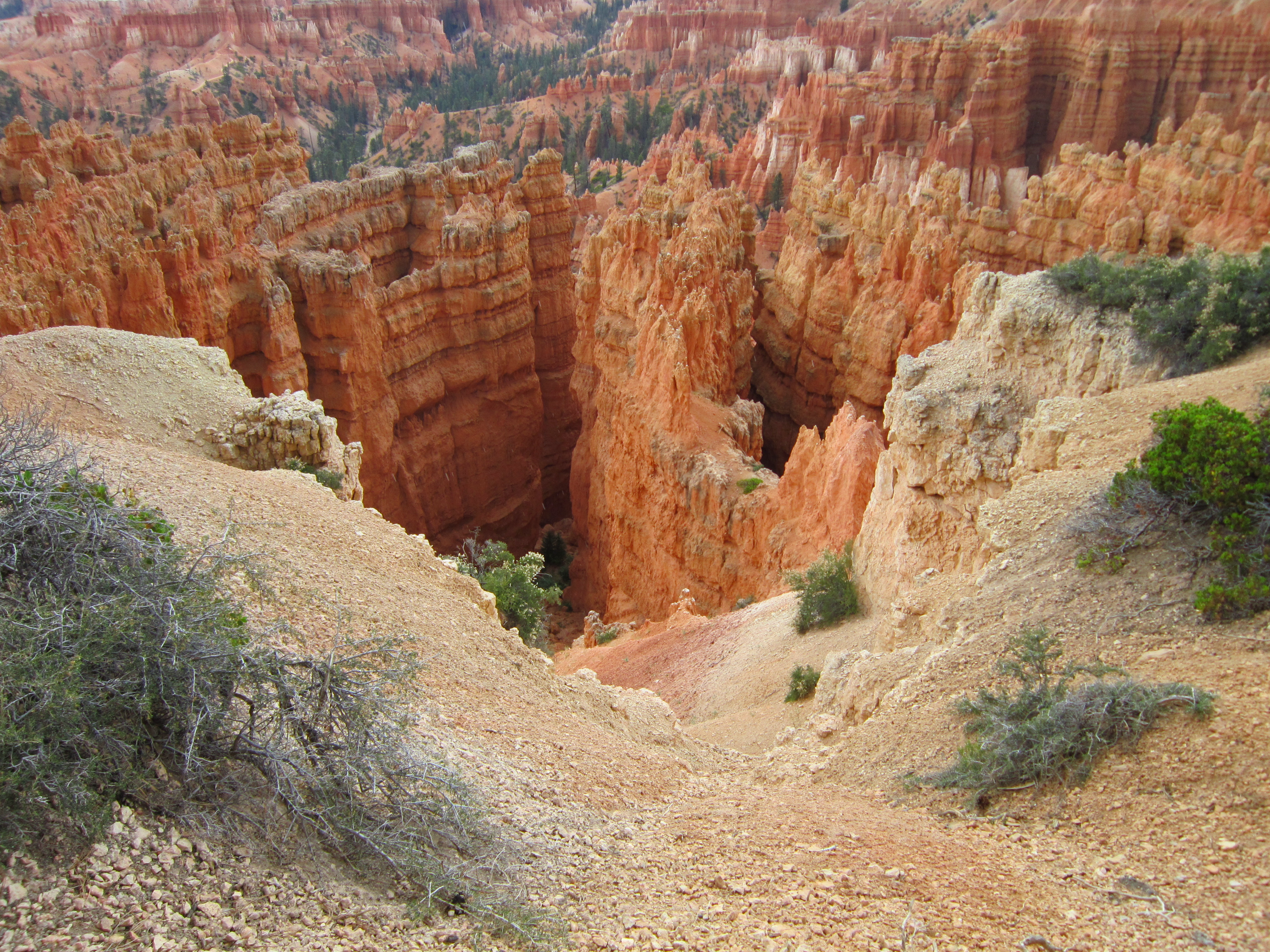
Every time I mentioned Utah to anyone as I was preparing for my trip, I was told that I had to go to Bryce Canyon. Well, all right, then, everyone; I went to Bryce Canyon. And Red Canyon. And, so, okay, you were right.
It’s a fairly long and roundabout ride from here to the canyons, but when you arrive it all comes as a surprise.
Red Canyon comes first. As we approached Bryce, I could see some ridges in the distance with the layers of red and brown that are so much a part of the scenery through Utah, but even with these hints, I was unprepared as we came around a long curve and the walls turned red all around. The road runs right against the walls along the floor of the canyon, and through it in two places where arches have been cut in the sandstone. I was so mesmerized by the color and by the literally fantastic columns and cliffs, that I didn’t have time to think about my camera, and had to resolve to get some pictures on the way back out.
As we continued on to Bryce Canyon, the road started to rise. I asked if we would be driving into the canyon or going up to the rim. The rim it was, but I was expecting to see the canyon as we approached. Instead, the road turns up into a visitor area that looks like what you might expect a National Park to look. There are log buildings, beautifully appointed, places to camp and to picnic and to buy souvenirs and food. There are well-kept grounds to walk through and large parking areas for all the guests who come each year. It was busy on the fourth of July, and the walk through the crowds was an invitation to an ever-changing chorus of accents and languages. Then we arrived at the rim and I was struck speechless by what opened up in front of me. The solid ground disappeared on the other side of a short fence strung between square stone pillars. I stood by one of the pillars and looked over.
First some observations about the canyon itself, and then I want to talk about its impact.
Four things struck me about the canyon. First was the size. A mountain had become a hole in the ground as big as a mountain. Then there was the sculpturing of the earth by millions of years of wind and water. Tall, fragile spikes and columns, called hoodoos, seem to grow like flowers from the canyon floor. Tall figures loom over the landscape, like ghosts keeping watch. Trees grow from the columns, their roots exposed by the slow wearing away of the earth, keep digging deeper into the rock, so they appear to be standing on tiptoe, looking over the edge. The color seems unnatural, as though some mad artist had painted nature to match his fancy: pink and white, like a strawberry cake with icing applied by an insane baker. And the whole looks soft, not rock, but an enormous sand box with Tolkien sand castles scattered about.
I felt overwhelmed. All I could do was point my camera and click, and even at that I sometimes had trouble keeping my finger on the shutter button, and kept turning my camera off unintentionally. There are places on the Earth that can simultaneously make us feel insignificant and immortal. We are small compared to these wonders, but we walk around them and peer into their vastness like gods walking down from Olympus. The First Peoples spoke of the spirits of these canyons, and you don’t have to believe to hear them whispering.
I don’t know that I have done a particularly good job of conveying the experience, or at least of doing it justice. I was tempted to simply write, “Went to Bryce Canyon. Struck speechless.”
Of Rocks and Found Objects; and Art and Found Artists
In Travels With Myself on July 4, 2013 at 2:11 pmSometimes the most interesting things are the unexpected treats. Utah, I’ve discovered, is full of hidden treasures.
Last night, before getting ready for bed, I walked across the road from my motel to get a bite to eat and saw small converted gas station on the opposite corner. The sign said “Love the Art.” I went over and discovered that it was a gallery of stone sculpture and beads. The sop was closed, however, and so I went to bed. This morning I took my time getting started, knowing that I would only be going as far as Beryl, Utah. So when I drove out of the motel parking lot, I noticed that Love the Art was open, and I decided to stop in. Love the Art is an art and beading gallery owned and operated by David Penney and his daughters, Tina Robinson and Desiree Shotwell. The gallery specializes in stone sculpture and gemstone beads. They also serve espresso and coffee.
David Penney gets the rock from Zion, Utah, where he has personally discovered and named a stone called Picasso, a beautiful soft multi-colored stone in grays, ambers and blacks. All three of the owners are sculptors ad they sell a lot of their own work out of the store. They also sell work by other artists around the world who trade some of their pieces as partial payment for shipments of more stone to carve.
Tina was working in the store today and we had a lovely conversation about topics ranging from art and stonework to beading to children, to what it’s like living and working as an artist in Utah and opening a gallery just off the highway in a place called Beaver. In the end I found that I could not resist a Picasso heart to be made into a pennant and a small romantic carving of two horses lying side by side. All of the work was absolutely wonderful, from the whimsical to the highly sophisticated. Large abstract stone sculpture mounted on a desert wood pillar was exquisite.
I remarked to Tina as I was leaving that I would certainly tell people about Love the Art, and that it was always a thrill for me to find artists and artisans living and working in small towns and little shops. This sentiment was made even stronger for me later in the day.
I am staying for a few days with my sister Linda in Beryl, Utah. Linda has a weaving and fiber store called R Ewe Spinning, in Enterprise, about 15 miles down the road from her home in Beryl. After I arrived, Linda and I decided to get a light lunch in Enterprise, so that she could show me around a bit. We went, of course, to see Linda’s store, which shares half of a small building with a stone beads and jewelry store run by a delightful woman named Sandy. R Ewe Spinning is filled with racks of yarn ad fiber, spinning wheels, sewing notions, and beautiful, fun, practical, and original knitted objects created the people who work there, notable Tisha, one of Linda’s daughters-in-law, who was behind the counter: wonderful little knitted booties, some shape like actual boots, one pair a set of knitted “sandals”; clever knitted diaper cover and hat sets; and a remarkable sleeved shawl. Sandy’s shop is festooned with strings of beads and racks of necklaces, there are bowls of stone beads and displays of local stone like snowflake obsidian.
We also stopped was to visit a friend of hers named Joe. Joe makes the most wonderful (and I mean that literally) constructions out of wood, found items (such as old bicycles, a horse’s skull, abandoned toys, old automobiles and other assorted vehicles, and a chaotic assortment of metal parts of all kinds. In his front yard he has an incredible display of his creations, all of which are completely fanciful, but many of which look like they really ought to work that way: a seven foot tall “bicycle” with a large front wheel and a tiny tricycle pushing it along from behind and an old auto headlight mounted on the front with eyelashes; a “locomotive” made of random found objects and a wooden frame, and several tree-slab tables with found-wood pedestal legs. Joe is also a builder of useful things, like an incredible barn-board hutch that lives in Linda’s kitchen. Next to Joe’s house is a small open log cabin that Joe disassembled, moved to his property, and put back together. And I have to mention the horse. A horse’s skull found in the desert has grown with the bleached bones of old trees and other salvaged wood, plus an old ragged saddle into a whole new horse, that stands waiting by the fence.
These artists and artisans and their creations don’t just drop here randomly or accidently. When I say that I am always delighted and surprised at finding such art in isolated places, it is an admission of my own forgetfulness. I am accustomed to seeing similar shops and studios in the tourist clogged little towns of New England – Mystic, CT, for instance, or virtually the whole of Cape Cod. And it’s easy to think that the tourism is what allows the art to survive. Artists like Tisha and Tina and Joe and Sandy exist because art itself is a basic human activity; ad because they have chosen to live in places that feed their souls and their art. The best art, I believe, is organic, it is fed by the artist’s relationship to her, or his, life. That is what delights me: seeing the art that each new place helps to create because artists live there.
